7-Day Returns
Free Shipping $250+
Fast
Delivery
Ordering for a school or district?
Submit Purchase Orders with Net-30 Day Terms. Registered Tax-exempt Accounts Supported.
National Geographic
World Classic Map, Mural
$124.95
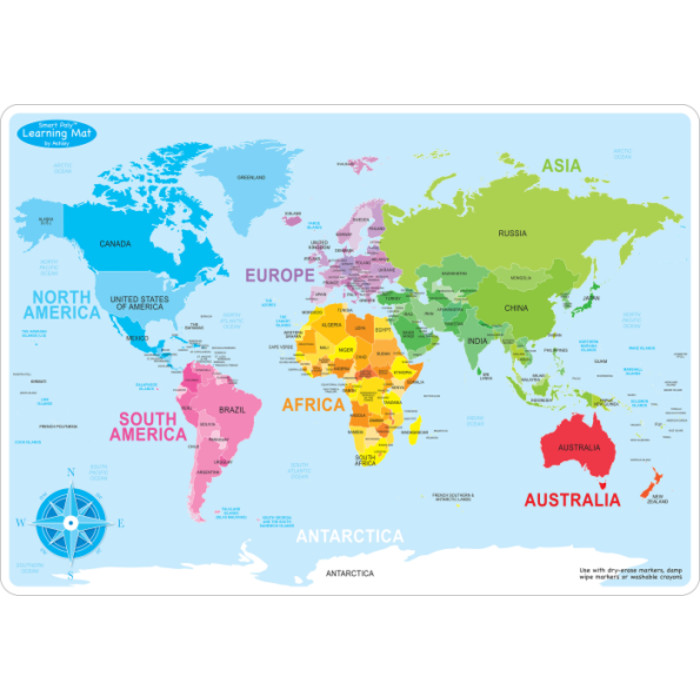
Embark on a captivating journey around the globe with National Geographic's World Classic Map, now available in a stunning mural format that brings the world to life in vivid detail. Expertly researched and designed, this map stands as the…
Read more
- Age Group
- 14+ years
- Grade Level
- Grade 9+
- Material
- Paper
- Color
- Multi
In stock — 36 available
Expected back in stock: Jun 29, 2026
Embark on a captivating journey around the globe with National Geographic's World Classic Map, now available in a stunning mural format that brings the world to life in vivid detail. Expertly researched and designed, this map stands as the authoritative reference for the world, meticulously crafted to provide unparalleled accuracy and detail. Featuring National Geographic's signature Classic style with a bright color palette and colorful borders, this map offers clarity and readability that make it an indispensable tool for exploration and education.
From the towering peaks of the Himalayas to the sprawling coastlines of the Pacific, every geographic feature is depicted with precision, thanks to the subtle shaded relief and meticulously labeled landforms. Major water bodies, including rivers, lakes, and oceans, are clearly delineated, while accurately defined international boundaries, cities, islands, and airports provide essential geographic context. Thousands of place names are strategically placed to ensure legibility, even in heavily populated areas, offering a comprehensive overview of the world's rich tapestry of cultures and landscapes. Drawn in Winkel Tripel projection, distortions are minimized, providing a more accurate representation of the Earth's surface. Corner inset maps offer additional insights into vegetation, land use, population density, and the polar regions, enriching the viewer's understanding of global patterns and phenomena. Up-to-date international boundaries and territorial control reflect de facto status on the ground. Printed on tear-resistant, coated paper for strength and color protection, this mural map is built to last, with a dirt and dust-resistant coating that can be easily cleaned with a damp cloth. The mural can be hung using heavy duty (clay based) wallpaper paste. Whether you're a student, traveler, or geography enthusiast, the National Geographic World Classic Map, in mural format, is an indispensable tool for unraveling the mysteries and marvels of our planet.
From the towering peaks of the Himalayas to the sprawling coastlines of the Pacific, every geographic feature is depicted with precision, thanks to the subtle shaded relief and meticulously labeled landforms. Major water bodies, including rivers, lakes, and oceans, are clearly delineated, while accurately defined international boundaries, cities, islands, and airports provide essential geographic context. Thousands of place names are strategically placed to ensure legibility, even in heavily populated areas, offering a comprehensive overview of the world's rich tapestry of cultures and landscapes. Drawn in Winkel Tripel projection, distortions are minimized, providing a more accurate representation of the Earth's surface. Corner inset maps offer additional insights into vegetation, land use, population density, and the polar regions, enriching the viewer's understanding of global patterns and phenomena. Up-to-date international boundaries and territorial control reflect de facto status on the ground. Printed on tear-resistant, coated paper for strength and color protection, this mural map is built to last, with a dirt and dust-resistant coating that can be easily cleaned with a damp cloth. The mural can be hung using heavy duty (clay based) wallpaper paste. Whether you're a student, traveler, or geography enthusiast, the National Geographic World Classic Map, in mural format, is an indispensable tool for unraveling the mysteries and marvels of our planet.
Key Features
- Signature Classic style map with bright, easy to read color palette with blue oceans and colorful borders
- Background shows mountain ranges and valleys in subtle shaded relief with mountain ranges labeled
- Major water bodies including rivers, lakes, glaciers, oceans, seas, gulfs, bays, straits, and bathymetry
- Clearly defined international boundaries, cities, islands, airports, and physical features
- Thousands of place names carefully and artfully placed to maintain legibility in heavily populated areas
- Measures 110" x 76.5"
| Age | 14+ years |
|---|---|
| Assembly Required | Yes |
| Balloon | No |
| Battery Included | N |
| Brand | National Geographic |
| CSI Part (cross-ref) | NG-RE00622007 |
| Color | Multi |
| Contains Aerosol | No |
| Contains Chemicals | No |
| Contains Pesticide/Herbicide/Fungicide | No |
| Contains a Circuit Board | No |
| Contains a Light Bulb | No |
| Contains a Marble | No |
| Contains a Small Ball | No |
| Contains or is a Small Magnet | No |
| Eco Friendly | No |
| Free Flowing Liquid | No |
| Grade | Grade 9+ |
| Has Warranty | No |
| Height (in) | 4.000000 |
| ISBN (Mfr Reference) | 9780792294580 |
| Is a Marble | No |
| Is a Small Ball | No |
| Length (in) | 41.000000 |
| Marketing / Educational Features | Wall Reference Maps |
| Material | Paper |
| Media Mail Eligible | No |
| Package Contains | 1 Map |
| Package Count | 1 |
| Product Series | Wall Maps |
| Registered with WERCS | N |
| Regulated by the US FDA | No |
| Sharp Points or Edges | Yes |
| Size | 110" x 76.5" |
| Small Parts | No |
| Suitable for Consumption | No |
| Unit of Measure | EA |
| Vendor | NATIONAL GEOGRAPHIC MAPS |
| Width (in) | 4.000000 |
Write Your Own Review
No active discounts apply to this product right now.
Related Products